Save to shopping list
Create a new shopping list
Safe shopping
Idosell security badge
Pix4Dsurvey - Yearly Subscription (1 device)

Pix4Dsurvey - Yearly Subscription (1 device)

Regular price net incl. VAT / szt.
1 751,86 €
net / szt.
2 154,79 €
incl. VAT / szt.
You can also buy using:
14 days for easy returns
This product is not available in a stationary store
Safe shopping
Product sold out
You will receive an email notification from us when the product is available again.
Data is processed in accordance with the privacy policy. By submitting data, you accept privacy policy provisions.
Contact details entered above are not used to send newsletters or other advertisements. When you sign up to be notified, you hereby agree to receive only a one-time notification of a product re-availability.
Brand

Pix4Dsurvey

Bridge the gap between photogrammetry and CAD

Capture

Capture images or point clouds with a drone or any laser scanner.

When using a drone, automate and optimize your flights with the free Pix4Dcapture mobile app.

Model

Transform your images into digital point clouds, and import them into Pix4Dsurvey. Work directly with Pix4Dmapper files, or any .las or .laz file.


Vectorize

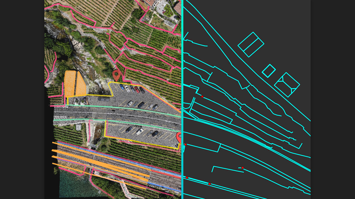
Create engineering-ready CAD files from point cloud data by extracting key elements of your project with Pix4Dsurvey.


Integrate

Open your simplified, accurate data in any CAD or GIS software with custom layers and properties that fit your existing workflow.


Beyond the point

Extract only the most relevant information to speed up and simplify your surveying workflows.

Vectorize anything

Flexible & scalable

CAD ready

Use the combined power of images and point clouds to extract key elements from photogrammetry, laser scanning or LiDAR data. Survey curbs, building footprints, walls, catenary curves and more.

Work with small to very large projects. More than one photogrammetry or laser scanning file can be worked on at once, easily.

Include layers and properties for a smooth transition to CAD or GIS and reduce file size when exporting your projects as vector files.

Extract key elements in 3D

Integrated solution

Pix4Dsurvey works with your existing workflows. Import .p4d files from Pix4Dmapper at the click of a button, or work with LAS files.

Scale up

Pix4Dsurvey can handle billions of points. Work with more than one point cloud file at a time, in the same project.

Unlock more data

Move beyond photogrammetry, yet still work with Pix4D’s rayCloud to access the original images and 3D point clouds simultaneously. Even complex objects such as catenaries only visible in images can be surveyed.

Built-in vectorization tools

Vectorize your project using points, polylines, polygons and catenary curves with just a few clicks.

Easy export

Every surveyed object can be assigned to a layer and edited. Layers can be exported separately or together for a smooth transition to your preferred CAD or GIS software.

Your choice of point cloud

Import projects from Pix4Dmapper, or any .las or .laz file.

Aerial data

Create a point cloud from images in Pix4Dmapper, and drag and drop the .p4d file to Pix4Dsurvey.

Laser or LiDAR

Pix4Dsurvey works with any point cloud formatted as a .las or .laz file.

Do you need help? Do you have any questions?Ask a question and we'll respond promptly, publishing the most interesting questions and answers for others.
Ask a question
If this description is not sufficient, please send us a question to this product. We will reply as soon as possible. Data is processed in accordance with the privacy policy. By submitting data, you accept privacy policy provisions.
Write your opinion
Your opinion:
5/5
Add your own product photo:

We care about your privacy

This page uses cookie files to provide its services in accordance to Cookies Usage Policy. You can determine conditions of storing or access to cookie files in your web browser. More information on terms and conditions and privacy can also be found on Google's Privacy and Terms page.

Close
pixel